Severe Weather Risk in North TX
March 31, 2008 at 5:51 am | Posted in Uncategorized | Leave a comment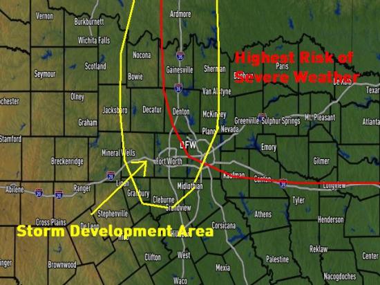
Changes for the weekend…
March 28, 2008 at 7:38 am | Posted in Uncategorized | Leave a commentA late March cold front is moving across North Texas.
Thursday highs were in the mid 80s, but by Friday afternoon, temps will be nearly 30 degrees cooler, in the mid/upper 50s.
The moisture is deep enough for some sprinkles and clouds on Friday, but will gradually deepen to the point of a few scattered showers on Saturday and Sunday.
Right now, it looks like the highest rain chances will be Friday night and Saturday morning, and even then, the showers should be light and widely scattered.
As a stronger front moves our way on Monday, we’ll see an increased risk of severe storms Monday afternoon and evening.
More wind for Wednesday
March 26, 2008 at 7:18 am | Posted in Uncategorized | Leave a comment
After a very windy Tuesday, the south wind will continue strong Wednesday as well. A wind advisory is in effect today.
DFW recorded a wind gust of 39 mph on Tuesday, and other spots had winds gusting above 40mph.
Terrell: 41mph
Corsicana: 40mph
Sherman: 43mph
Our Wednesday winds (say that three times, fast!) won’t be quite as strong, but we’ll still see some winds gusting up around the 30-35 mph range.
We’re beginning to dry out from the rain last week, and the wind is starting to increase the fire danger a bit. A Fire Weather Watch is in effect today for high fire danger, generally west of the metroplex.
A breezy week!
March 24, 2008 at 7:20 am | Posted in Uncategorized | Leave a commentAfter a very wet week last week, finally, some typical March weather moves in.
Windy and warmer weather are in store for most of us.
By Monday afternoon, the wind may get close to 20mph, and with some wind Monday night and Tuesday morning, our low temperatures on Tuesday morning will be much milder, from 45-49 degrees.
The wind on Tuesday, Wednesday and Thursday will be stronger, 20 to 25 mph all week, so the March wind we’re used to will be here in full force all week!
Dallas/Fort Worth Easter Weather
March 23, 2008 at 4:45 pm | Posted in Uncategorized | Leave a commentHappy Easter.
Below is a link to the National Weather Service history of Easter weather in the Dallas/Fort Worth area.
http://www.srh.noaa.gov/fwd/CLIMO/dfw/holiday/deaster.html
Enjoy,
Steve Mac
It’s been a very wet March so far
March 20, 2008 at 4:30 pm | Posted in Uncategorized | Leave a commentTags: burn ban, flood, rain, spring
DFW Airport reported 2.35 inches of rain on March 18. That was an all-time record for the date. And an additional 0.32″fell after midnight, into the early morning of the 19th. So DFW’s total rainfall was 2.67″. That’s pretty impressive.
But much of Dallas, Collin, Fannin, Ellis, western Hunt and northern Hill Counties had twice as much rain. Those counties had 4.5 to 6.5 inches of rain.
But the 2.67″ total at DFW is what goes into the record books. So for the first 20 days of March, DFW has now received 5.96″ of rain. And that means this now ranks as the 6th wettest March ever. Here are the records:
1. 2002 7.39″
2. 1995 6.69″
3. 1968 6.39″
4. 1979 6.33″
5. 1945 6.19″
6. 2008 5.96″
And we still have 10 days left in this month to add to our total. We expect another round of thunderstorms late Saturday night into Sunday morning. That means we should climb higher on the list of rainiest Marches.
Of course, from October through February, it had been very dry across Texas. Nearly 200 counties were under Burn Bans. And grassfires and brushfires were spreading rapidly in many areas. But after the recent rains, and the green-up from the onset of spring, many of those county burn bans have been lifted. Here is a link to a map showing the burn bans that still remain in effect: http://tfsfrp.tamu.edu/wildfires/DecBan.png

CLICK ON THE MAP TO SEE THE IMAGE FULL SIZE
Another reminder: Spring began today at 12:48 am. And the Spring season is usually our stormiest time of the year. Our greatest threat for severe thunderstorms occurs from mid March into mid June. We will have a lot more on those threats tonight at 6:30 pm on our annual special, Tracking Texas Weather. I hope you can watch.
Check out “Tracking Texas Weather” tonight
March 20, 2008 at 10:52 am | Posted in Uncategorized | Leave a commentWe’ve got a great show for you this evening at 6:30pm on NBC5.
Meteorologist Steve MacLaughlin talks to a man that was hit by last year’s Haltom City tornado. We’ll hear his survival story as the tornado was bearing down on him. He’ll also speak with a photographer, who took pictures of the approaching tornado!
Chief Meteorologist David Finfrock shows us the extremes of drought and flooding that we’ve seen in the last three years.
Meteorologist James Aydelott will guide us through our new interactive radar on nbc5i.com, and the new animated radar on m.nbc5i.com-its perfect for your iPhone, Blackberry or other internet capable cell phone!
We’ve got more technology to share-NBC5’s Scott Gordon takes us through how we get live video from our Stormtracker H3 to your tv!
We’re providing weather information to you on our HD NBC5 channel as well! We’ll explain how we crawl weather information in full HD!
We’re proud of this year’s edition of Tracking Texas Weather. Its new, its HD, and our crew, both the meteorologists, and the highly skilled behind the scenes folks have worked hard to bring you this great show.
See you this evening!
Talk about a Gully Washer!
March 19, 2008 at 11:09 am | Posted in Uncategorized | Leave a commentThe Tuesday rain was indeed a gully washer!
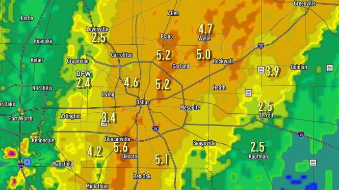
Take a look at some of these rain totals:
Officially DFW received 2.7″
Above 5″
Rowlett 5.0″
Honey Grove 7.2″
Lancaster 5.1″
Duncanville 5.6″
Richardson 5.0″
White Rock Lake 5.2″
4-5″
Celina 4.14″
Anna 4.8″
McKinney 4.3″
Wylie 4.8″
Greenville 3.9″
Waxahachie 4.3″
Maypearl 4.0″
Cedar Hill 4.2″
Love Field 4.6″
Grand Prairie 4.2″
Paris 4.0″
3-4″
Commerce 3.9″
Lake Lavon 3.7″
Cleburne 3.7″
Cooper 3.6″
Celeste 3.6″
Carrollton 3.5″
Caddo Mills 3.9″
Mineral Wells 3.3″
Perrin 3.4″
Jacksboro 3.1″
Graham 3.1″
Weatherford 3.1″
![]()


A Rainy Tuesday
March 18, 2008 at 12:00 pm | Posted in Uncategorized | Leave a comment
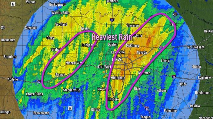
Rainfall totals as of 7am Tuesday
Its always good when we can get beneficial rain without much severe weather-and that’s what’s happening today.
We’ll see average rains from 1 to 2 inches across North Texas, with some spots seeing 3 to 4 inches.
This whole mess will finally move out tomorrow morning, and we may see some sunshine by Wednesday afternoon.
Severe Weather Outlook – Monday
March 17, 2008 at 1:30 pm | Posted in Uncategorized | Leave a comment
Recent Comments
marion on Amazing Photos of Ike’s… Bookmarks about Hurr… on Record Breaking, but well Beha… Nanette Walton on Too Hot for a Hannah Montana S… Julie on Let me hear it! By Jennifer… Kari on Let me hear it! By Jennifer… - Visit the other NBC 5 Blogs by clicking this icon.

Blog at WordPress.com.
Entries and comments feeds.
